
Archive Record
Images
Metadata
Object Name |
Map |
Catalog Number |
2018.058.0005b |
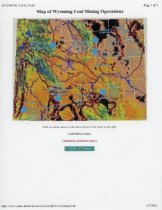
Scope & Content |
Map of Wyoming coal mining operations that was printed from the Wyoming Mining Association's website that is no longer active (http://www.wma-minelife.com/ coal/coalfrm/coalmap.htm). The map contains areas that are marked as coal fields, coal regions, and coal mines, with the majority of the mines located in the Powder River Basin in Northeastern Wyoming. |
Title |
Map of Wyoming Coal Mining Operations |
Date |
2005, June 07 |
Year Range from |
2005 |
Year Range to |
2005 |
Search Terms |
Belle Ayr Coal Mine Black Thunder Mine Buckskin Mine Caballo Mine Coal Creek Mine Cordero Rojo Mine Dry Fork Mine Eagle Butte Mine Jacobs Ranch Mine North Antelope Mine Powder River Basin Rawhide Mine Rochelle Mine Wyodak Coal Mine |
Subjects |
Coal Coal Industry Coal mining Maps |