
Search Term Record
Metadata
Name |
City Hall |
Related Records
-
-
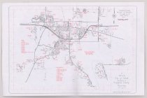
Map, Road - 2018.058.0032
Map of Campbell County roads is located on one side and a map of Gillette is on the other side. The Campbell County Map shows the coal mines in red striped boundaries; a list of street names and the map index is located to the right of the map. The Gillette Map was compiled by the City of Gillette in 1991. It has public buildings, schools, and parks and open spaced marked in red, with streets and highways in black.
Record Type: Archive
-
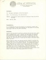
Memorandum - 1974.048.0420
A memorandum to the mayor and city council members from the city administrator concerning the architectural service contract for design of new city office building.
Record Type: Archive
-
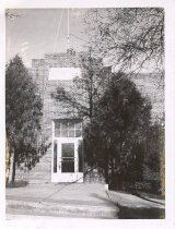
Print, Photographic - 2006.012.0094
A B/W Polaroid photograph of the exterior of Gillette City Hall on Gillette Ave.
Record Type: Photo

-
Print, Photographic - 2006.012.0095
A B/W Polaroid photograph of the exterior of Gillette City Hall on Gillette Ave.
Record Type: Photo

-
Print, Photographic - 2006.012.0097
A B/W Polaroid photograph of the exterior of Gillette City Hall on Gillette, Ave.
Record Type: Photo
-
Records - 1974.048.0229a - b
A list of the Judges of Election that were appointed for the General election to be held on November 5, 1912, two pages long.
Record Type: Archive
