Search Term Record
Metadata
Name |
North Antelope Mine |
Related Records
-
History - 2018.058.0020a-n
Packet of information about Cyprus Amax Coal Company, achievements in the coal industry in Wyoming, the larger impact of coal, surface coal mining, backfilling and land reclamation, shipping history and other records from 1972-1995 for Eagle Butte Mine and Belle Ayr Mine, employment statistics, mining equipment descriptions, geological summary of the Wyodak coal seam of the Eastern Powder River Basin, table of 1994 coal production numbers for eac...
Record Type: Archive
-
History - 2018.058.0038a-n
Packet of information about achievements in the coal industry in Wyoming, the impact of coal, open pit coal mining, backfilling and land reclamation, shipping history and other records from 1972-1993 for Eagle Butte Mine and Belle Ayr Mine, employment statistics, mining equipment descriptions, geological summary of the Wyodak coal seam of the Eastern Powder River Basin, table of 1992 coal production numbers for each Powder River Basin mine, and a...
Record Type: Archive
-
List - 2018.058.0003a-c
List of frequently asked questions about coal formation and coal mining, with statistics from the national and Wyoming state coal industry.
Record Type: Archive
-
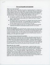
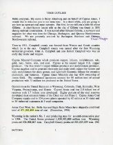
List - 2018.058.0019a-i
Coal mine tour outline created on behalf of Cyprus Amax. The first page contains a script by Betsy Altenburg about the history of Gillette, Campbell County, and Cyprus Amax. The remaining document contains facts about coal, different areas of Belle Ayr Mine, and highlighted topics that were discussed to explain the history and process of coal mining. The pages are numbered 1 through 10, but there is no page 5.
Record Type: Archive
-
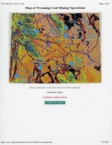
Map - 2018.058.0005b
Map of Wyoming coal mining operations that was printed from the Wyoming Mining Association's website that is no longer active (http://www.wma-minelife.com/ coal/coalfrm/coalmap.htm). The map contains areas that are marked as coal fields, coal regions, and coal mines, with the majority of the mines located in the Powder River Basin in Northeastern Wyoming.
Record Type: Archive
-
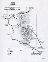
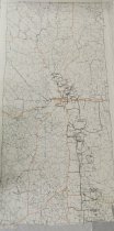
Map - 2018.058.0017
Map of the Burlington Northern Railroad tracks and projected tracks in the Powder River Basin. The operating coal mines and projected coal mines (several of which were never opened) are marked along the railroad tracks. According to the donor, this map was given to Belle Ayr Mine by the Burlington Northern Railroad Company and was used to provide information on mine tours.
Record Type: Archive
-
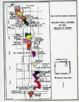
Map - 2018.058.0029
Map of active and inactive coal mines in Campbell County. The mine sections have been filled with colors that occasionally repeat; there is no map key, so it can be assumed that the colors only differentiate the mines from each other and the rest of the map.
Record Type: Archive
-
-
-
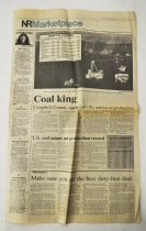
Newspaper - 2018.004.0074
Section of The News-Record, including pages 13 through 20. It includes news about annual coal production from various mines.
Record Type: Archive
-
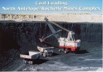
Postcard, Picture - 2017.052.0004
Unused color photo postcard of coal loading at North Antelope/Rochelle Mines Complex in Campbell County, WY. Captioned on the back, "An early 1960's vintage Model 291-M Marion electric shovel weighing 1055 tons loads a Euclid Model R-170 haul truck with 170 tons of coal. These Electric drive trucks weigh 112 tons empty and are powered with 16V Detroit 1600 horsepower diesel engines. The trucks cost about $1.0 million when they were new in th...
Record Type: Photo
-
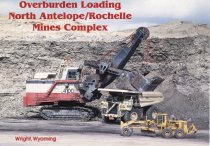
Postcard, Picture - 2017.052.0012
Unused color photo postcard of overburden loading at North Antelope/Rochelle Mines Complex in Campbell County, WY. Captioned on the back, "A $1.8 million Caterpillar Model 793 haul truck, weighing 160 tons empty, powered by a 2160 horsepower diesel engine is being loaded with 255 tons of overburden. The $9 million P & H Model 4100 electric shovel loads with a 55 cubic yard capacity bucket." Part of a set of postcards: "Postcard Coal Minin...
Record Type: Photo